
Tai Mo Shan and Ng Tung Chai Waterfalls: A Magical Journey Up HK's Tallest Mountain
Contents
- Essential Information
- Hike Highlights
- Google Route Map and GPX File
- How to Get There
- Quick Route Summary
- Ng Tung Chai Road to the Start of the Trail
- The Walk to the First Waterfall
- Bottom Fall
- Walking to Middle Fall
- Middle Fall
- Walking to the Unnamed Waterfall
- Unnamed Waterfall
- Walking to Main Fall
- Main Fall
- Walking to Scatter Fall
- Scatter Fall
- IMPORTANT FORK IN THE PATH
- Optional Detour: Lead Mine Pass
- The Final Ascent Up to Tai Mo Shan Peak
- The Descent
- How to Get Back
Essential Tai Mo Shan and Ng Tung Chai Hike Details
- District: New Territories
- Duration: 3.5 - 4 hours (at a fast pace with no time added for swimming)
- Distance: 13km
- Highest Elevation: 957 meters
- Difficulty: 4.5/5
- Facilities: None until near the end of the hike, so bring plenty of water and use the toilet beforehand
Tai Mo Shan and Ng Tung Chai Hike Highlights


The Tai Mo Shan and Ng Tung Chai hike can essentially be split into two distinct sections. The first part comprises a shaded forest section that goes past five different waterfalls: Bottom Fall, Middle Fall, Main Fall, Scattered Fall and an unnamed waterfall.
This section is pretty vertical and has a lot of stone steps, which requires a decent level of cardio. This section can be manageable for beginners by spending time relaxing in each pool and splitting the route into four or five parts.
The second part is the trudge up to Tai Mo Shan. This part is punctuated by a boring concrete road that steeply winds its way up to the peak. This part of the hike is unshaded and loses all the nature that made the waterfall section so special.
After reaching the top, your effort will be rewarded with panoramic views across all of Hong Kong! Enjoy the views as you descend down Route Twisk for 40-45 minutes to the bus stop.
Google Route Map and GPX File
How to Get to The Ng Tung Chai and Tai Mo Shan Hike Start Point


64K bus that goes directly to the start point, which is different depending on which direction you get the bus from.
No matter if you take the bus from Tai Po Market Station, Tai Wo Station or Yuen Long Station, you will need to get off the bus at Ngau Len Wo Stop.
I took the bus from Tai Po Market Station, so the above directions are from there.
Quick Ng Tung Chai and Tai Mo Shan Hike Summary

- Get the 64K bus from either Tai Po Market Station, Tai Wo Station or Yuen Long Station and get off at the Ngau Len Wo Stop.
- Follow Ng Tung Chai Road for around 15-20 minutes past the little village and temple entrance before you'll arrive at the start of the trail.
- Follow the brown sign that says 'To Waterfalls'.
- A short while later, you'll come across a set of signs. Follow the one pointing to 'Tai Mo Shan (Via Waterfalls).
- Follow the trail for 15 minutes. You will then see a sign pointing to 'Bottom Fall' Follow it down the stairs to reach the first waterfall.
- Climb back up the stairs and follow the sign pointing to 'Tai Mo Shan'
- Just a couple of minutes later, you'll see a brown sign pointing to 'Middle Fall'. You will find the waterfall just a minute away from the sign.
- Retrace your steps back to the 'Middle Fall' brown sign and look for the stone steps just to the left of it. Begin climbing.
- Follow the trail for 10-15 minutes and you'll come across an unnamed waterfall with no sign to mark it.
- Continue following the stone steps upward and soon the trail will open up a little.
- About 10 minutes later, you will arrive at a brown sign marking the 'Main Fall'.
- Head across the main fall and the trail will continue from the opposite side of the pool.
- Keep following the trail for another 5 minutes before you'll arrive at 'Scatter Fall'.
- Continue up the stone stairs when you're done and take the RIGHT fork about 5 mins later.
- Follow the trail past old ruins and troupes of monkeys until you see a sign pointing to 'Tai Mo Shan' before a set of stone stairs.
- Follow the sign and walk past a bamboo forest before following the trail for 25-30 minutes.
- You will arrive at a brown shelter where you can take an optional detour or begin the final ascent up to Tai Mo Shan
- Optional detour: head left by following the 'Lead Mine Pass' sign and begin climbing up the stairs until you reach the grassland. There are AMAZING views here. The detour takes about 15 minutes and will require some climbing.
- Retrace your steps back down to the brown shelter when you're done exploring and follow the brown sign pointing to 'Route Twisk'. If you don't want to do the Lead Mine Pass Detour, just follow the 'Route Twisk' sign from the brown shelter.
- Walk up the steep concrete road for 25-30 mins until you arrive at the Tai Mo Shan Weather Station and the PLA Army base at the top of the mountain.
- Follow Route Twisk all the way down to the main road which takes about an hour. You can catch the 51 bus from there to Tsuen Wan MTR.
Ng Tung Chai Road to the Start of the Trail


After getting off the bus, you'll have to follow Ng Tung Chai Road for 15-20 minutes. There are a few signs along the way to point you in the direction of the Ng Tung Chai Waterfall trail.
You'll eventually head past Yung Nga Kok village. At the end of the village, the trail will take you into a more forested area. After passing a little field, you'll arrive at an epic temple.
Just past the temple is the start of the trail. You can tell when the trail begins because the concrete road is replaced with a natural path.
The Walk to the First Waterfall


You'll be following the trail for about 15 minutes. Pay attention to the signs along the way which will point you in the right direction from time to time. To be fair, there's only really one direction you can go in, so it's hard to get lost during this portion of the hike.
Just pay attention to the 'Tai Mo Shan' sign about 15 minutes into the trail. Just below it is a brown sign pointing to 'Bottom Fall'. If you miss that sign, you'll end up missing the first waterfall entirely.
Bottom Fall


Bottom Fall is a great spot to take a little break from the stone steps. The pool here is relatively deep, so you can easily chill out in the water and enjoy a short break before continuing your ascent.
As far as grandeur is concerned, when I visited, Bottom Fall was one of the shortest waterfalls I saw.
Walking to Middle Fall


You'll have to retrace your steps back to the 'Tai Mo Shan' sign after exploring Bottom Fall.
From there, take the stairs upward for just a few minutes and you'll come across a brown 'Middle Fall' sign, indicating that you've arrived at the second waterfall.
Middle Fall


Middle Fall is much more impressive than Bottom Fall in terms of height, but there isn't much depth to the pool. This means while you can cool off a little in the water here, you're not going to really be able to swim much.
The pool might be deeper at other times of the year, so your experience could be totally different to mine.
Walking to the Unnamed Waterfall


This is one of my favorite sections on the whole hike. Though it only lasts about 10-15 minutes, it's shaded, cool and really natural. There's a specific stone path that looked particularly amazing.
There's a lot of cardio involved, but since the whole area is shaded, it's not as tough as expected.
Unnamed Waterfall


Unnamed Fall is actually a hidden gem. It has possibly the best pool in which to swim and the force of the waterfall isn't too powerful, so it's pretty safe.
Again, all this information is only pertinent to my own experience. The conditions may be totally different when you visit.
Walking to Main Fall


This section takes about 10 minutes and is relatively easy to follow. Simply stay on the trail, enjoy a few open sections and before long, you'll arrive at Main Fall!
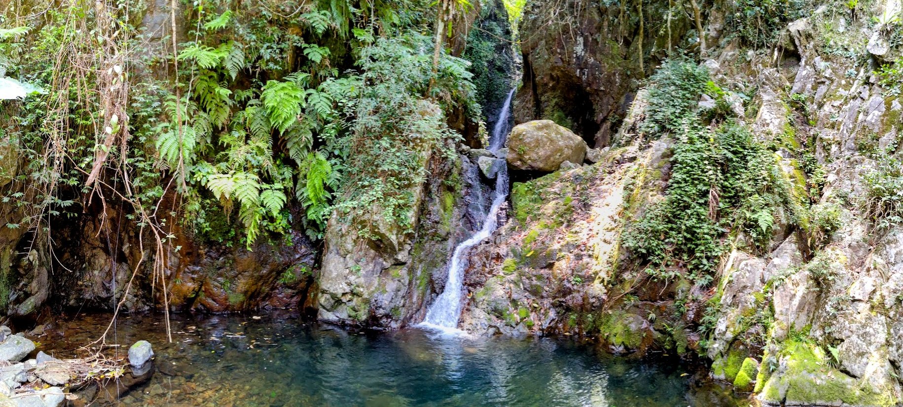
Main Fall


Main Fall is the tallest out of all the Ng Tung Chai waterfalls. It's a genuinely impressive sight, but the pool is shallow here and not really great for swimming in.
To reach the next section of the hike, you'll need to head across the rocks to the other side of the pool.
Walking to Scatter Fall


It takes only 7-10 minutes to get to Scatter Fall from Main Fall. Though there are a few stone stairs to navigate, the trail rewards you with some of the coolest trees, which grow with a unique slant to them before shooting upward.
Truly one of Hong Kong's most unique sections of trails!
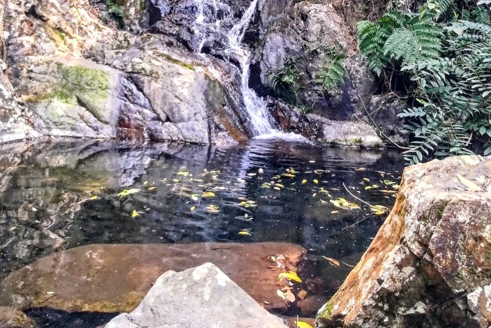
Scatter Fall


Though Scatter Fall is rather small, it's pretty scenic. The pool isn't large enough to swim in but the various paths that the water takes when cascading downward is likely what gives this cute little waterfall its name.
To continue on the hike, take the stairs up on the right of the waterfall.
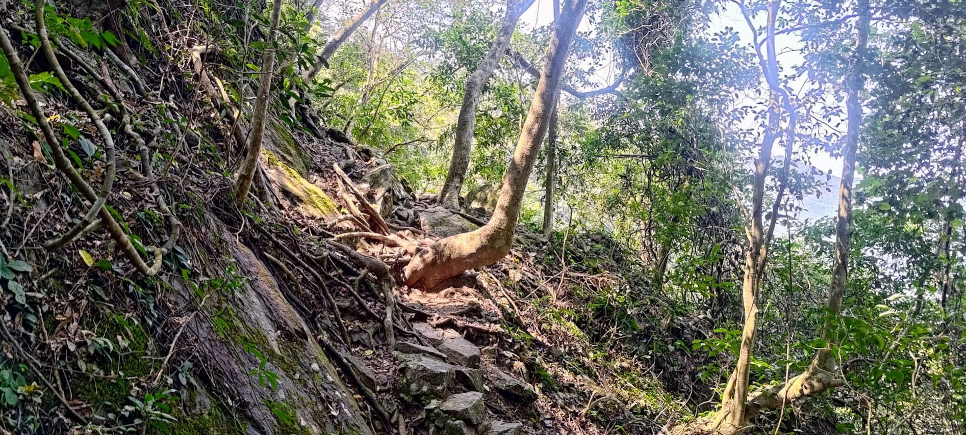
IMPORTANT FORK IN THE PATH


This section of the hike takes about 40 minutes. After taking a RIGHT TURN at the fork, you will just follow the trail until you arrive at a sign pointing toward 'Tai Mo Shan'.
Take the steps upward and enjoy the shade while you can. Before long, you will emerge from the trees and arrive at a wooden shelter, where the next portion of the hike will begin. This is also where all the shade ends. If it's a hot day, expect to roast.
Optional Detour: Lead Mine Pass


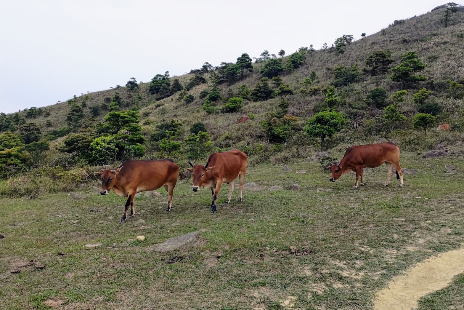


This detour will take a minimum of 20 minutes, but can take much longer depending on how far into Lead Mine Pass you want to explore. If you keep following this detour, you can technically end up all the way down at Shing Mun Reservoir, but you'll not reach the peak of Tai Mo Shan if you choose this route.
Once you're done exploring, you should retrace your steps and return back to the wooden shelter to begin the steep ascent up Tai Mo Shan.
(The above pictures were taken in 2021 (cows), 2022 (green epic views) and 2024 (stairs).

The Final Ascent Up to Tai Mo Shan Peak


It'll take about 25-30 minutes to reach the top of Tai Mo Shan from the 'Route Twisk' sign beside the brown shelter. You'll be climbing up a boring concrete road that's seriously steep, so prepare to feel that sweet burn in your calves!
There are a few intermittent viewpoints with famous mountains like Lion Rock to distract you on the way up, but for the most part it's you versus the steep road.
Enjoy!
The Descent


Heading down to the bus stop from the top of Tai Mo Shan is pretty brutal in that there are initially some incredible views and then you'll be stuck winding down a concrete road for around 45 minutes to an hour.
You'll likely be pretty tired from the hike and since the entire downhill section is unshaded, you'll be under the sun the whole time.
Worse still, this road (Route Twisk) is frequented by cars which you'll have to avoid from time to time.
When you reach the bottom of the road, take a right and you'll see the bus stop about 2-3 minutes later.
If you're thirsty, you can get a drink from the refreshment kiosk pictured above.
Getting back
Take the number 51 bus to Tsuen Wan MTR station where you can take the train anywhere in the city.
You can also grab buses all over Hong Kong from near the MTR Station.

