
A Comprehensive Timeline of the Largest and Deadliest Typhoons in Hong Kong History
Contents
- Hong Kong's Typhoon Warning Signal System
- Why Typhoons Affect Hong Kong So Severely
- Timeline of 8 Worst Typhoons in Hong Kong History
- The Typhoon of 1874
- 1906 Hong Kong Typhoon
- 1937 Great Hong Kong Typhoon
- Typhoon Wanda (1962)
- Typhoon Rose (1971)
- Typhoon Ellen (1983)
- Typhoon Hato (2017)
- Typhoon Mangkhut (2018)
- Advice for Residents During Typhoons
- Should you Tape Your Windows During a Typhoon?
Hong Kong's Typhoon Warning Signal System
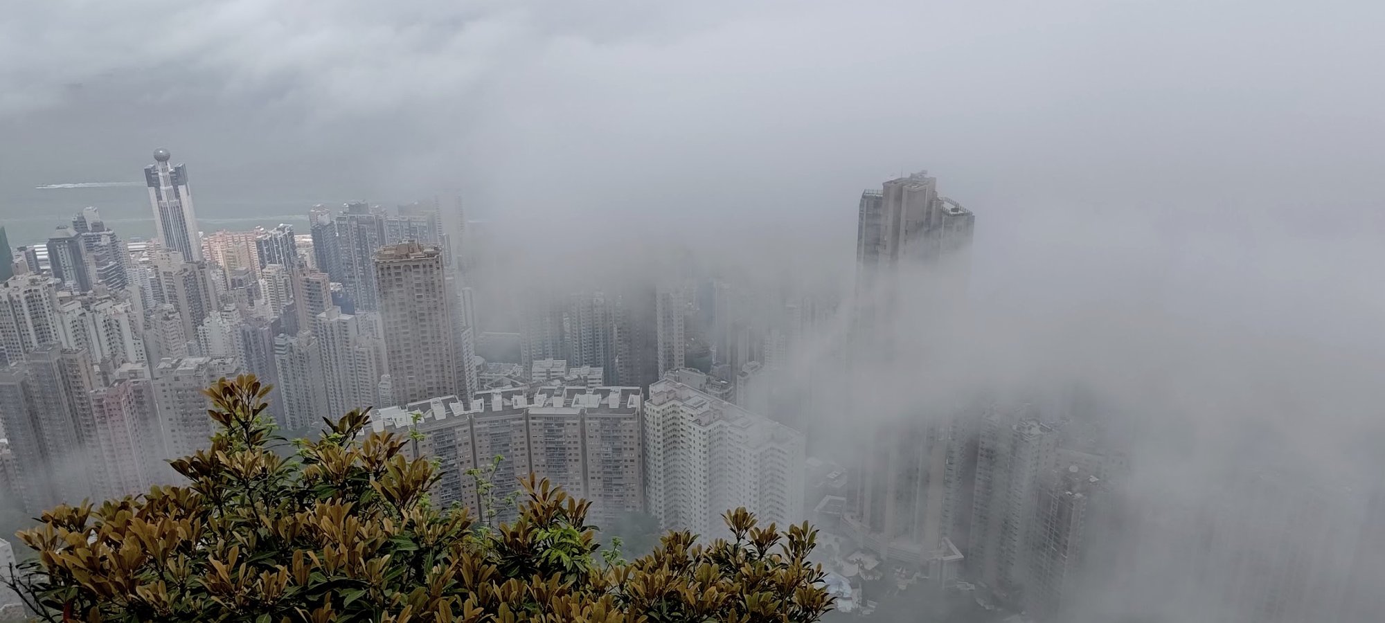
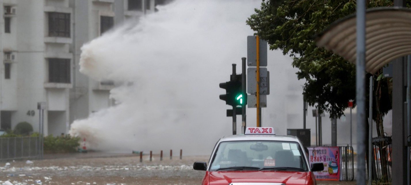
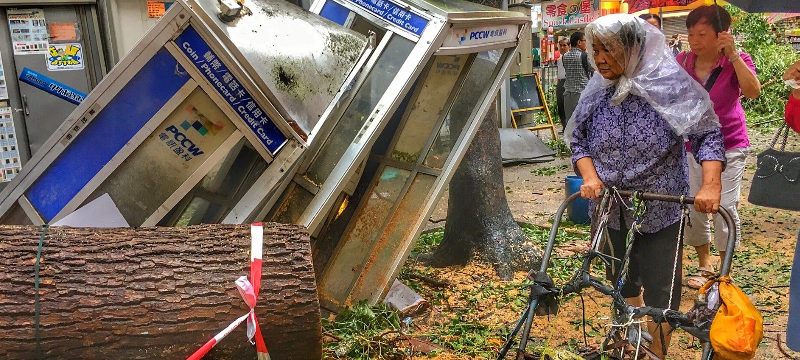
Hong Kong is one of the world’s most typhoon-prone cities.
I say this as tropical storm Ragasa rages outside and is supposedly going to be even stronger than Typhoon Mangkhut - the strongest typhoon in Hong Kong history.
It's also probably one of the only places in the world where residents actively hope for typhoons to roll around because of the possibility of work being cancelled.
The city's unique typhoon signaling system dictates how severe typhoons are and how much of a halt the city will come to as a result. Below is a full list of typhoon signals and what they mean in Hong Kong:
Standby Signal No. 1
- Formal Meaning: A tropical cyclone is within approximately 800 kilometers of Hong Kong and may affect the territory.
- As Hong Kongers See It: Is there an asthmatic mouse blowing air at me?
- Actions: Stay updated on weather information. No significant impact on daily activities is expected at this stage.
Strong Wind Signal No. 3
- Formal Meaning: Strong winds of 41 to 62 km/h are expected or blowing near sea level, with gusts possibly exceeding 110 km/h.
- As Hong Kongers See It: My fan generates more of a breeze than this! Can I still drop my child off at daycare?
- Actions: Secure loose outdoor objects. Small boats should return to port. Some schools may close. Public transport and businesses generally continue, but with caution.
No. 8 Gale or Storm Signal (Four variants: Northwest, Southwest, Northeast, Southeast)
- Formal Meaning: Gale or storm force winds of 63 to 117 km/h are expected or blowing near sea level, with stronger gusts (up to 180 km/h).
- As Hong Kongers See It: Don't need to go to work! Why are so many of these on the weekends?
- Actions: Offices, schools, shops, and outdoor facilities close. Public transport, ferries, and flights are usually suspended. Stay indoors and secure property.
Increasing Gale or Storm Signal No. 9
- Formal Meaning: Gale or hurricane force winds are increasing or expected to increase significantly.
- As Hong Kongers See It: Oh wow, this is going to be a big storm! Gonna take it seriously.
- Actions: This signals the approach of a serious typhoon. Take full safety precautions, stay indoors, and prepare for severe weather.
Hurricane Signal No. 10
- Formal Meaning: Hurricane force winds exceeding 118 km/h, with gusts that may exceed 220 km/h, are blowing or expected in the area.
- As Hong Kongers See It: Let's put two flimsy lines of cheap tape on our windows in an X-shape to protect against hurricane-force winds. Also, so many Instantgram videos of the storm going around!
- Actions: This is the highest alert. Stay indoors and away from windows and doors. Expect severe damage potential, power outages, and restricted access post-storm.
Why Typhoons Affect Hong Kong So Severely
The city's location on the south coast of China, along the Pearl River Delta, places it directly in the path of many tropical cyclones originating in the western Pacific and the South China Sea.
The nearby warm ocean waters supply energy to these storms, allowing them to maintain or even increase intensity near land. At the same time, Hong Kong's mountainous topography amplifies impacts: torrential rainfall often leads to landslides, while storm surges funnel into Victoria Harbour and low-lying areas, magnifying flooding risks.
The western North Pacific Ocean is the most active tropical cyclone basin globally, producing roughly 25–30 named storms annually, with about 6–8 approaching the South China region.
Hong Kong’s unique mix of dense urban development, mountainous terrain, and coastal vulnerability means that when powerful typhoons make landfall or pass nearby, they can leave behind catastrophic impacts on life and infrastructure.
A Timeline of the 8 Worst Typhoons in Hong Kong's History
- The Typhoon of 1874
One of the deadliest typhoons in Hong Kong’s history, killing thousands. - 1906 Typhoon
Caused catastrophic loss of life at sea. - 1937 Typhoon
Among the worst disasters in modern Hong Kong history with heavy casualties and damage. - 1962: Typhoon Wanda
Extremely destructive with record-setting wind speeds. - 1971: Typhoon Rose
Caused severe damage and was associated with a major shipping tragedy. - 1983: Typhoon Ellen
Resulted in heavy damage to infrastructure and widespread disruption. - 2017: Typhoon Hato
Brought severe storm surges and destructive winds across the territory. - 2018: Typhoon Mangkhut
One of the strongest typhoons ever to strike Hong Kong, causing extensive damage.
The Typhoon of 1874
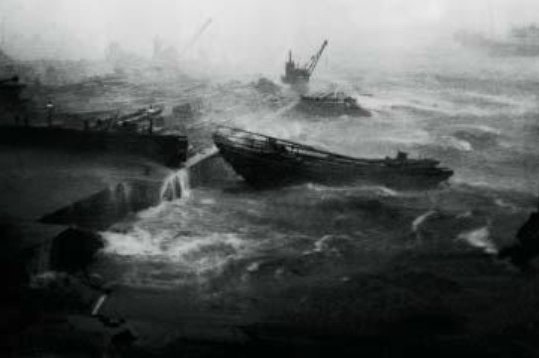
On September 22 and 23, 1874, Hong Kong was struck by what remains one of the most devastating typhoons in its history. This storm caught the city by surprise, as early warning systems were rudimentary at the time. The typhoon packed immense winds and generated storm surges that swept into Victoria Harbour and surrounding coastal communities.
The devastation was unprecedented: an estimated "2,000 souls" were lost, according to a news report in the Sacramento Daily Union, published on 10 November 1874. Hundreds of ships were destroyed or badly damaged. Onshore, entire villages were obliterated, wooden houses were flattened, and large parts of the city were left in ruins.
The disaster prompted the colonial authorities to establish more systematic weather monitoring, eventually leading to more advanced meteorological tools being created, which eventually led to the founding of the Hong Kong Observatory in 1883. More than just a meteorological tragedy, the 1874 typhoon changed the way the city prepared for natural disasters.
An article in Nature published on 31 December 1874 described the typhoon in comparison to two others in the years prior: "The whole of these phenomena [previous two typhoons] sink into utter insignificance when compared with the furious typhoon which swept over the island during the night of the 22nd and the morning of the 23rd of September last. Without speaking of the dire effects produced by the latter, tenfold more terrible than any hitherto experienced."
Summing up the devastation left in the wake of the typhoon, an article from the Hong Kong Daily Press published on 24th September, 1874, read, "At times, even above the fierce howling of the wind could be heard the pitiful cries of thousands, vainly battling with the storm. Dead bodies in all directions washed ashore ... The flag staff at the Peak was seen leaning at an angle, a sad signal to ships miles away of the ravages to which the Colony had been subjected."
1906 Hong Kong Typhoon
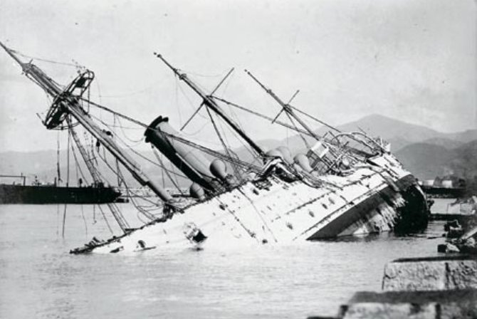

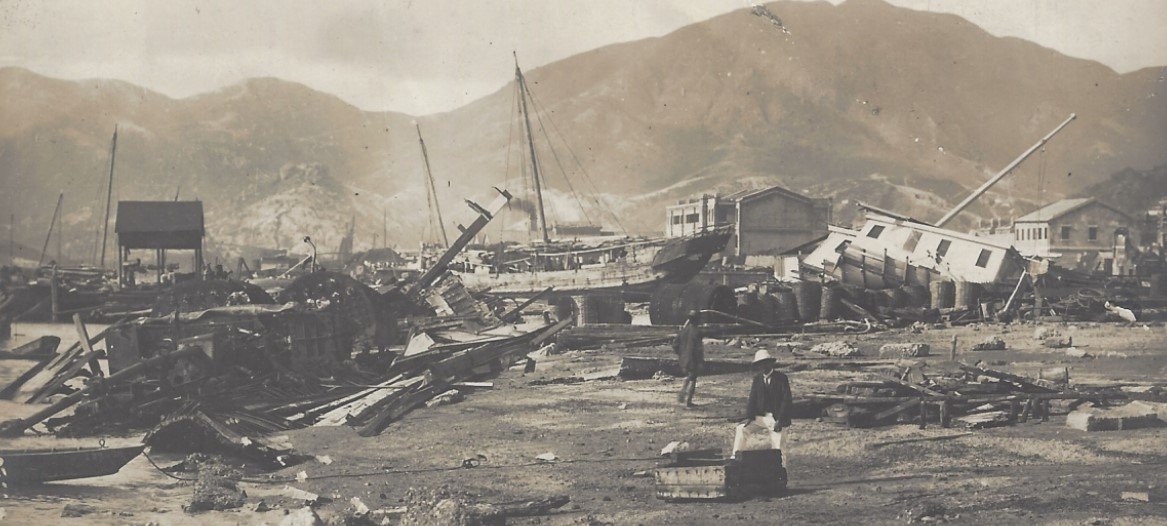
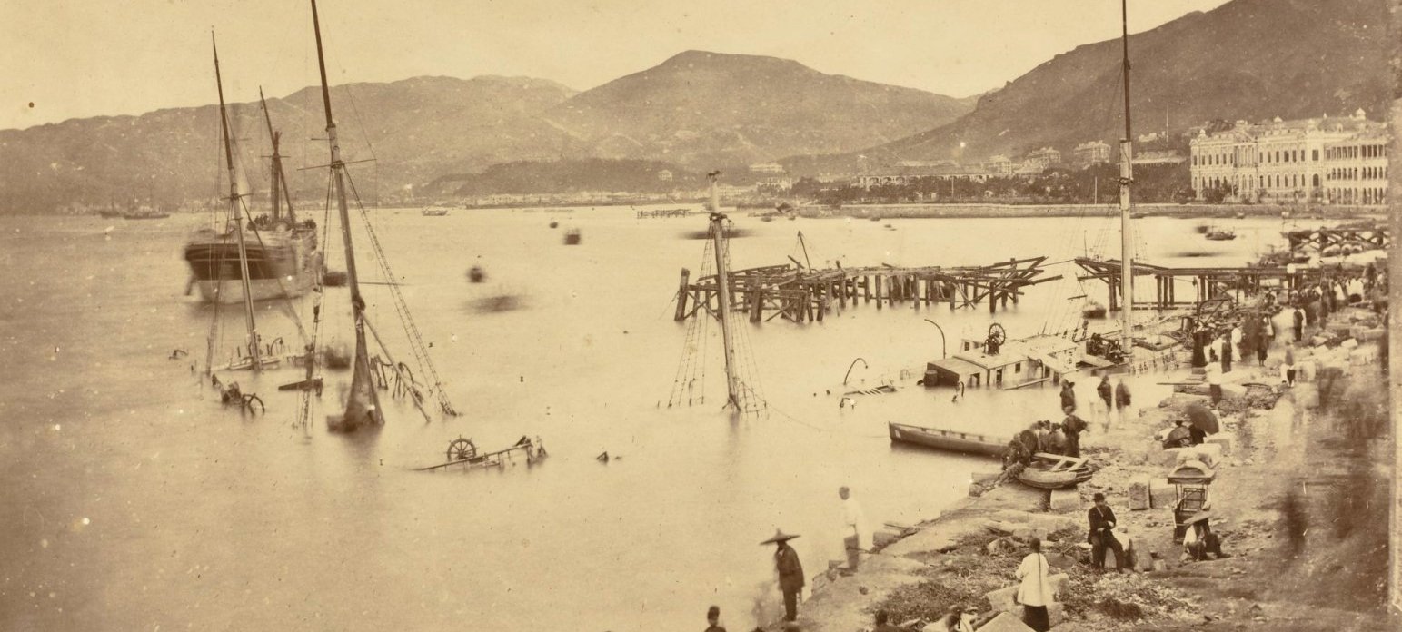
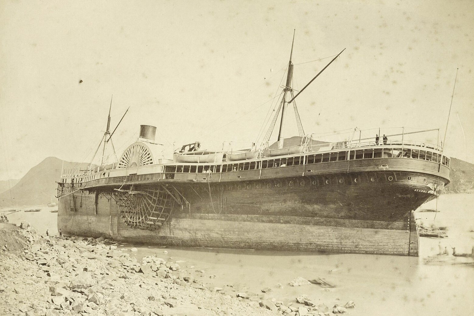
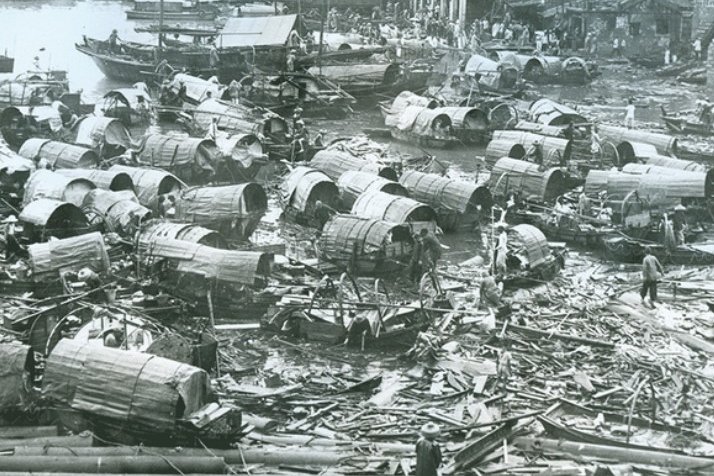
The typhoon of September 18, 1906, is regarded as one of the deadliest natural disasters in modern Hong Kong. The storm intensified rapidly before hitting the territory, whipping up extremely violent winds and massive waves. Within just two hours of gale-force winds, thousands of vessels in Victoria Harbour were destroyed and coastal infrastructure devastated.
The human cost was immense. A news article from Hong Kong Daily Press published on September 18, 1906, posited that the death toll was estimated at "4,000 to 10,000 people." The reason for such high loss of life is because this devastating storm was classified as a 'midget typhoon' that had a radius just 7–11 km. It "gave no indication of its existence until close to the colony," according to the same news story.
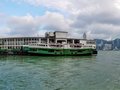
The maritime losses were devastating: up to 3,500 vessels wrecked, capsized, or sunk. Official tallies included 59 European merchant vessels damaged, 34 launches sunk, and around 1,796 native craft lost. Sampans and junks, especially were hard-hit by the typhoon as the fisherfolk of Victoria Harbour had zero warning or protection from the storm. Shoreline wharves, godowns, and piers also suffered extensive destruction. Included among these wharves was a recently-constructed wharf for the Star Ferry, which was totally destroyed.
Based on photo evidence of how far HMS Phoenix was raised above the water level, it is estimated that the sea level "might [have reached] about 4.3 mCD (meters above chart datum)."
An excerpt from The Advertiser, Adelaide, published October 13, 1906, summed up the scenes of destruction: "Immediately the belated boom of the warning gun was heard there ensued a scene of indescribable excitement and confusion. It was a kind of 'sauve qui peut' for the causeway. The bay junks and other vessels streamed for this point through the driving rain, colliding with each other, and cutting down houseboats, yachts, and other anchored craft in their mad career. Many never reached their goal, the terrific force of the wind twisting them out of all control. Hundreds were flung against the praya, the hapless crews in many instances being dashed to death in full view of the crowds on the shore, helpless to render any assistance. Even the larger sea-going and river steamers were like toys in the grasp of the roaring tornado, several being driven ashore and totally wrecked."
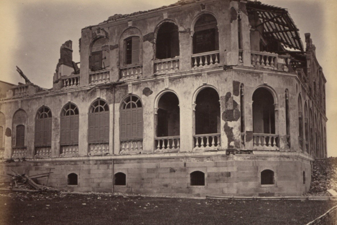
1937 Great Hong Kong Typhoon

The Hong Kong typhoon of September 1, 1937, was among the city’s most violent on record, with windsexceeding the Hong Kong Observatory’s measuring limits and contemporary estimates reaching roughly 240 km/h. It struck a harbor already crowded with ships and refugees fleeing fighting from the Sino-Japanese War in Shanghai, turning Victoria Harbour into a scene of chaos. Major liners tore free—most notably the Asama Maru drifting across the harbor to Chai Wan and the Conte Verde grounding near Cape Collinson before colliding with it—while many other vessels were damaged or sunk. Early counts put fatalities at least at 600, according to a news article from Time Magazine, published on September 13, 1937, though the true toll - especially among the poor and those at sea - was likely much higher. Some estimates go as high as 11,000 deaths in total, which would be equivalent to 1 percent of Hong Kong's population at the time.
The same Time Magazine article described the destruction of the typhoon: “Hundreds of fishing vessels and small Chinese houseboats were splintered against the sea wall and the rocky coast. Screaming coolies were catapulted into the seething water, many to be drowned, few to be saved by a life line of rope-tethered police and customs officers who strove spunkily, but hopelessly, against the storm.
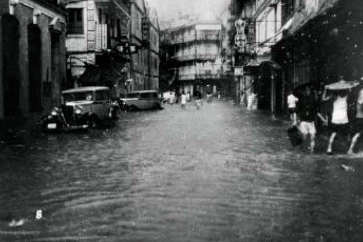
Across Central’s main arteries—Queen’s Road, Des Voeux Road, Pedder Street—floodwaters rose to the waist, buildings were stripped of roofs, and vehicles were left overturned. In working-class districts, flimsy homes and squatter shacks collapsed, with many deaths never fully recorded. Communications failed as wireless towers fell, complicating rescue efforts and leaving hospitals overwhelmed by injuries and the fires that swept shoreline districts and slums.
The disaster’s aftermath was grim and prolonged. Beyond the wrecked harbor and shattered commercial core, the storm left behind cholera, then typhoid and malaria, spreading through contaminated water, broken sanitation, and crowded refugee conditions. Scientific observers of the period noted both the ecological scouring of the coast and the civic devastation, underscoring how a six-hour blow cascaded into a months-long public-health crisis—one that revealed the fragility of infrastructure, the vulnerability of the city’s poorest, and the limits of emergency response in a colony already strained by regional war and displacement.
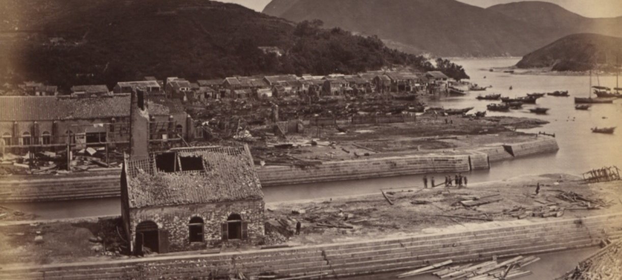
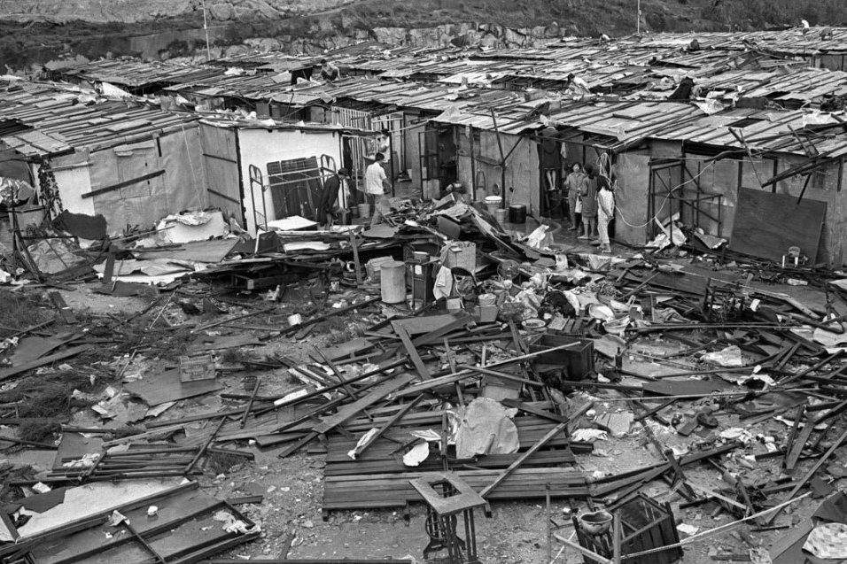
Typhoon Wanda (1962)

On 1 September, 1962, Typhoon Wanda struck Hong Kong after forming on 27 August and rapidly intensifying over the Luzon Strait. The Royal Observatory recorded a record low pressure of 953.2 mb and ten‑minute mean winds peaking near 78 knots, with gusts up to 140 knots recorded at the Observatory (Waglan Island and Tate’s Cairn reported extreme gusts).
Casualties and homelessness were severe: official colonial reports record about 1https://industrialhistoryhk.org/impact-of-typhoon-wanda-on-tolo-harbour/#_ednref5. Many fatalities occurred among boat communities and occupants of vulnerable huts and riverside dwellings.
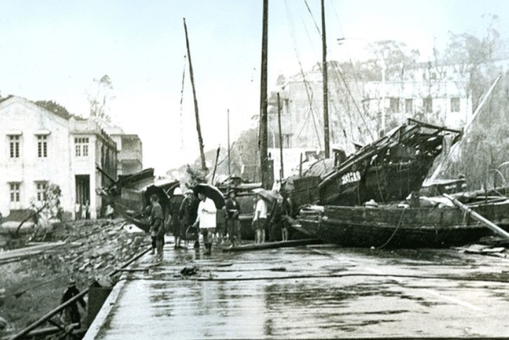
Maritime and coastal damage was extensive: of some 20,287 small craft in Colony waters, hundreds were sunk or damaged; several ocean‑going vessels were beached or sank.
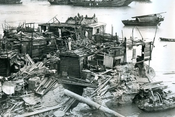
Property, infrastructure and agriculture suffered major losses. About 700 squatter and rooftop huts were destroyed and many more made uninhabitable; roads, the railway and bridges were blocked by boats and debris. Some 869 acres of farmland were flooded by seawater, resulting in about 280 acres of vegetable fields being ruined, and fruit plantations (bananas especially) suffered heavy damage. Over 300 fishing boats in Tolo Harbour were wrecked, and livestock and egg production fell markedly in rural districts.
Wanda remains one of Hong Kong’s most severe 20th‑century typhoons by wind, pressure, storm surge, and social impact, widely documented in meteorological reports and photographic archives.
An article published by the US Naval Observatory after the typhoon stated: "Typhoon Wanda gutted tenements in Hong Kong and left children only makeshift debris of damaged house[s]."
You can watch a video of the aftermath of Typhoon Wanda here.
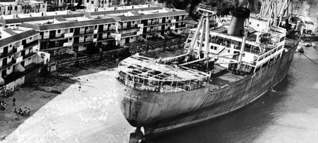
Typhoon Rose (1971)
Typhoon Rose, which struck Hong Kong from August 10 to 17, 1971, originated west of Guam on August 10. The typhoon's compact structure featured a 20-mile-wide eye and extreme wind speeds, with gusts reaching 150 knots (about 278 km/h) recorded on Tai Mo Shan, Hong Kong's highest peak. The highest sustained winds, near the center, were about 130 knots 240 km/h. There was plenty of flooding and disruption to the city's transport network.
Reporting on the typhoon, the Sarasota Journal wrote in August 17, 1971: "Typhoon Rose lashed Hong Kong with 155 mile per hour winds in the pre-drawn hours today. leaving a path of death and destruction in which a Hong Kong-Macao ferryboat capsized and 37 ships were driven aground. Authorities reported at least 25 persons died as result of the typhoon and its torrential rains. The death toll could rise much higher with at least 10 persons and possibly as many as 95 missing and feared dead. Forty persons were hospitalized and 300 others suffered lesser injuries."
The storm brought heavy rainfall, with a record 288.1 mm falling on August 17, causing severe flooding, numerous landslides, and disruption across the region.
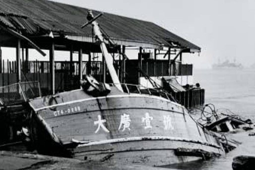
The destruction was widespread. The typhoon caused at least 110 confirmed deaths, including 88 fatalities from the tragic capsizing of the Hong Kong-Macau ferry Fatshan, which carried 92 people with only four survivors. An additional 286 people suffered injuries, with 90 hospitalized. Over 5,600 people from more than 1,000 families were left homeless, as 653 huts and 24 buildings were damaged or destroyed, six beyond repair.
Coastal and harbor areas saw massive maritime damage: over 30 ocean-going vessels ran aground or collided, about 300 small craft and pleasure boats were sunk or damaged, and six ferries went aground while seeking shelter. The heavy winds downed trees and uprooted scaffolding, while a major fire at a power substation in Kwun Tong caused widespread blackouts in Kowloon and the New Territories, trapping thousands in elevators, exacerbating the crisis.
You can watch an intriguing short video showing the typhoon's destruction here.
Typhoon Ellen (1983)
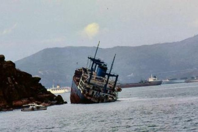
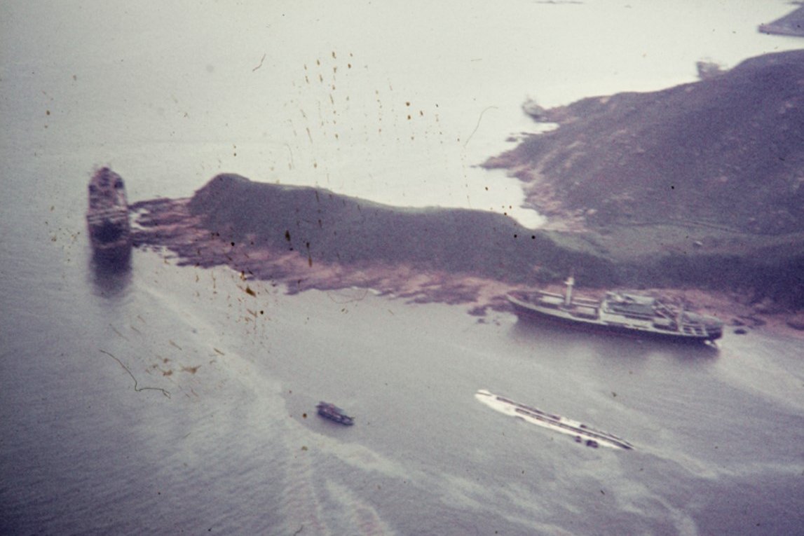
Typhoon Ellen lasted from August 29 – September 9, 1983. It was at its closest to Hong Kong around 7.00 a.m. on 9 September, passing just 7 nautical miles from the southwest tip of Lantau Island. The typhoon brought sustained hurricane-force winds and a maximum gust of 134 knots recorded at Stanley, with 128 knots at Cheung Chau and 122 knots at Waglan Island. The typhoon’s compact structure and slow movement contributed to prolonged intense wind conditions and heavy rainfall. The total recorded rainfall was over 230 mm at the Royal Observatory during the storm period, with a particularly heavy downpour on September 9.
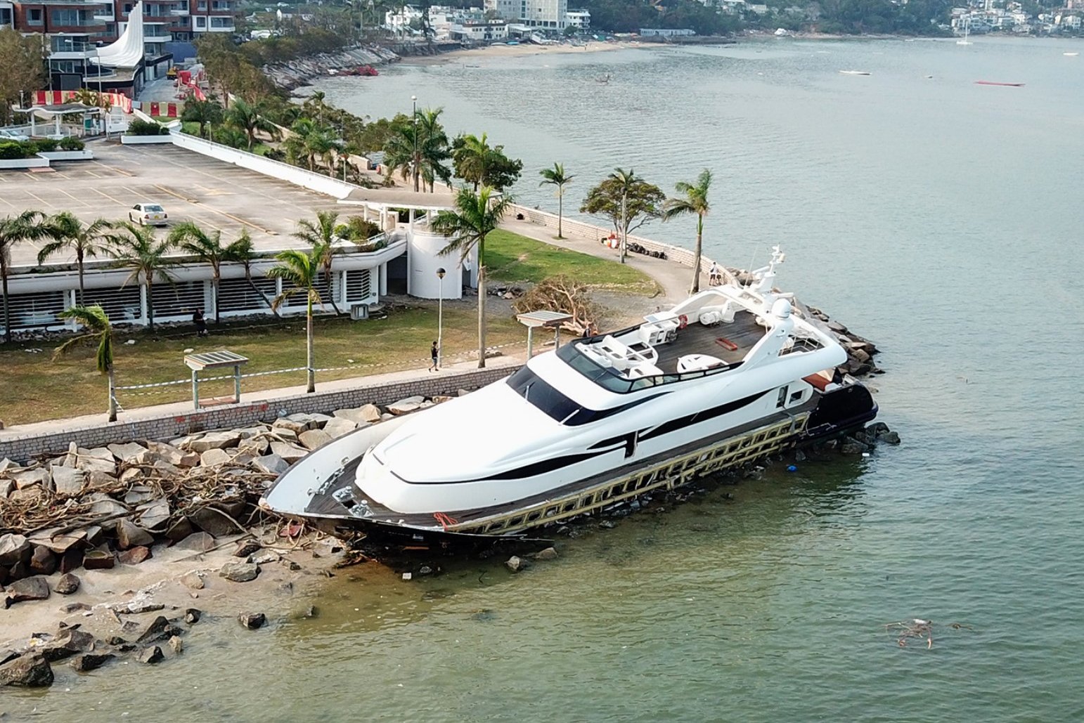
The human toll was significant:10 people were killed, 12 went missing, and 333 sustained injuries. The typhoon damaged or destroyed 274 huts, leaving approximately 1,600 homeless residents with mudslides causing even more widespread damage. Maritime losses included 44 ocean-going vessels in distress, with 26 ships (totaling roughly 250,000 tonnes) running aground, and many others involved in collisions. The pleasure yacht Osprey sank south of Hong Kong, with only one crew member saved. This incident contributed to a high percentage of typhoon-related deaths with 2 bodies found and 6 other crew members missing. The storm’s impact extended inland to flooding, landslides, and widespread damage to vegetation and agriculture — 1,500 hectares of crops were lost, alongside the death of 100,000 chickens and 2,300 pigs.
Power outages affected 80,000 households across Kowloon, the New Territories, and parts of Lantau, some lasting for over four days. Infrastructure damage was extensive with thousands of trees uprooted, numerous roads blocked by fallen debris, and over a thousand traffic lights damaged.
Typhoon Ellen also triggered Hong Kong's second-ever recorded tornado during the storm passage, causing minor damage but no injuries. Despite the destruction, the heavy rainfall helped replenish reservoirs, including the High Island Reservoir, which filled to capacity for the first time since its completion in 1978.
A news story published on September 9, 1983, in the St. Petersburg Independent stated "Typhoon Ellen killed at least six people and injured 180 others as it battered Hong Kong today with winds up to 140 miles an hour, spawning deadly mudslides and tearing freighters from their moorings. By mid-afternoon, the storm's center had moved past the British colony of 5 million people, leaving communications and public services paralyzed as it moved toward China's southern coastal province of Guangdong."

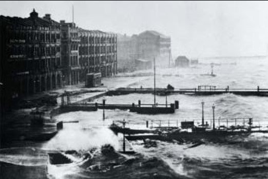
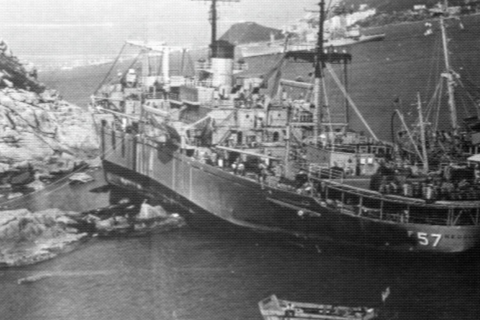
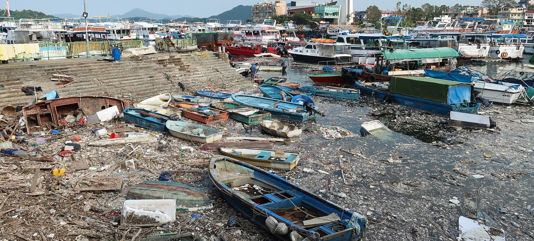
Typhoon Hato (2017)
Typhoon Hato is the first storm on the list that caused no casualties in Hong Kong, though eight people were killed in Macau. It affected the city on the morning of August 23, 2017, passing about 80 kilometers south-southwest of the region, triggering the No 10 signal. Hato brought sustained hurricane-force winds with peak gusts 193 km/h in some locations. Heavy rains and a severe storm surge caused extensive coastal flooding and property damage in multiple areas, including Tai O, Shek Pik, Mui Wo, Lei Yue Mun, and Tseung Kwan O.
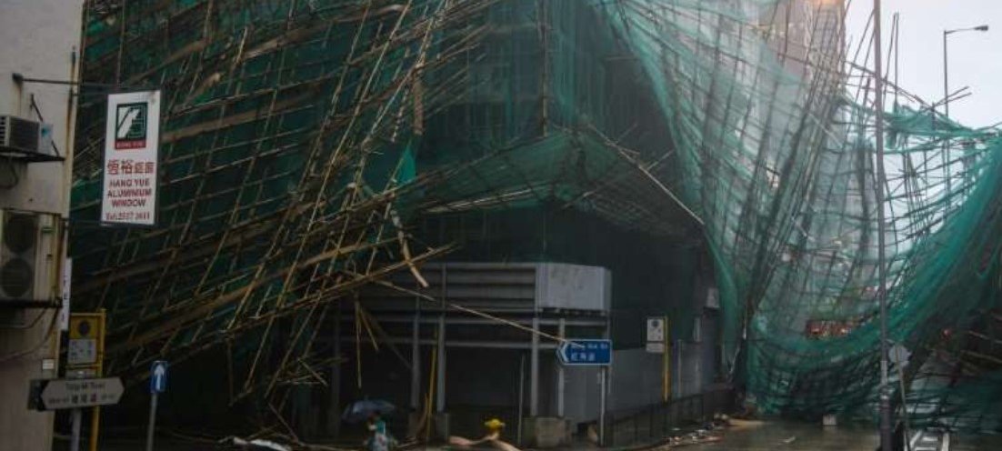
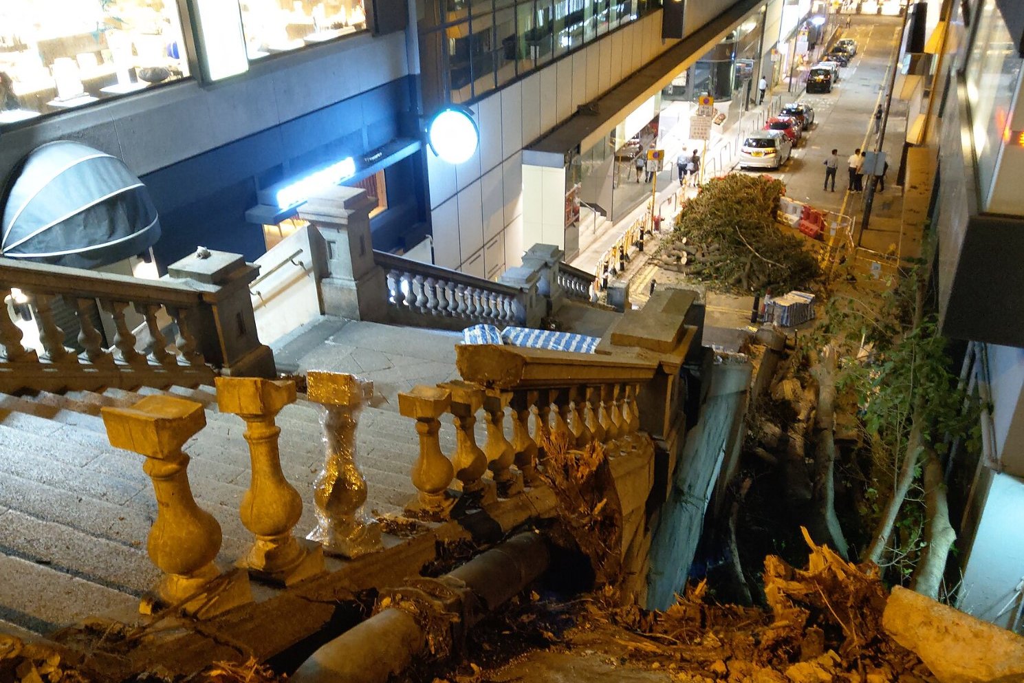
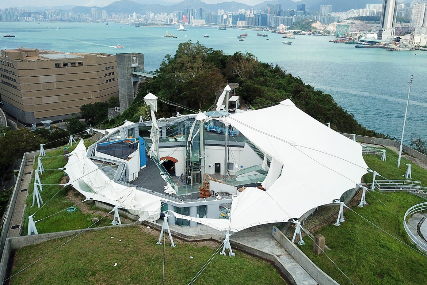
The typhoon resulted in at least 129 reported injuries in Hong Kong, including police officers and residents hit by falling debris. While no fatalities were recorded in Hong Kong, the storm's destruction was considerable. More than 5,300 trees were reported fallen, alongside multiple incidents of flooding, landslides, and road blockages. Significant damage occurred to buildings; glass curtain walls broke in Central and Wan Chai, scaffolding collapsed, and a suspended platform damaged apartments in Hung Hom. Over 480 flights were canceled, and numerous roads and ferry services were temporarily closed.
The storm surge peaked at over 2 meters above predicted levels at multiple coastal tide stations, flooding inland areas and trapping residents who required rescue. The extensive power outages disrupted many districts, with outages lasting several days in some places.
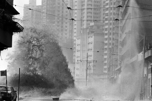
Typhoon Mangkhut (2018)


Typhoon Mangkhut, which hit Hong Kong on September 16, 2018, was the most intense typhoon to affect the city since records began, according to the South China Morning Post. The Hong Kong Observatory issued the Hurricane SignalNo 10 for 10 hours, marking the second-longest duration for this signal since World War II.
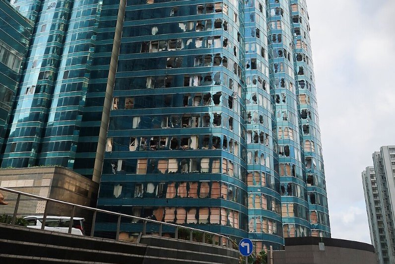
Mangkhut’s high winds were ferocious, with the maximum 60-minute mean wind speeds recorded at Waglan Island and Cheung Chau reaching 161 km/h and 157 km/h, respectively. Both figures represent the second-highest records at the corresponding stations, just lower than the record high of Ellen in 1983, and ended up shaking skyscrapers and devastating glass curtain walls, including those at the Harbour Grand Kowloon. The powerful winds brought down thousands of trees and disrupted transportation, blocking roads and halting MTR and ferry services. Around 900 flights were cancelled as a direct result of Typhoon Mangkhut.
The storm’s devastating impact extended to widespread flooding caused by a record-breaking storm surge that raised water levels by over 3 meters in some coastal areas, only lower than Typhoon Wanda.
Leung Wing-mo of the Hong Kong Meteorological Society said in a news article published on 18 September, 2018 , “The damage is extensive, particularly in the Sha Tin area. I’ve never seen anything like that – flooding of the Shing Mun river, to that extent."
Areas along the shoreline, such as Tai O, Shek Pik, Tseung Kwan O, and Lei Yue Mun, suffered severe damage. Over 40,000 households experienced power outages, some lasting multiple days. More than 200 people were injured, with many more affected by property damage and loss of services due to heavy flooding.
Advice for Residents During Typhoons
- Stay indoors once a T8, T9, or T10 signal is hoisted. High winds pose risks even in urban high-rises.
- Secure outdoor objects such as potted plants, drying racks, and signage to prevent them from becoming airborne.
- Stock emergency supplies like bottled water, canned food, batteries, and first aid kits in advance.
- Avoid flood-prone areas such as coastal promenades, basements, and low-lying neighborhoods.
- Monitor official updates through radio, mobile apps, or the Hong Kong Observatory’s website.
Does Taping Your Windows Protect Against Shattering During a Typhoon?

- The common belief that taping windows with duct tape or masking tape (especially in an X pattern) prevents glass from shattering is a myth.
- Tape does not strengthen glass or hold it together against the powerful impact of flying debris during a typhoon, according to the US Hurricane National Research Division.
- Instead, tape can cause the glass to break into larger, more dangerous shards that are loosely held, increasing the risk of injury.
- The force of a typhoon’s intense winds and debris impacts is simply too great for tape to offer effective protection.
- Time spent taping windows is better used on more reliable protective measures such as installing hurricane-rated impact windows or boarding up windows with plywood.
- Other methods like security films offer more protection but are often costly and time-consuming to apply under urgent conditions.

